Alentejo Megaliths

9 08 2011
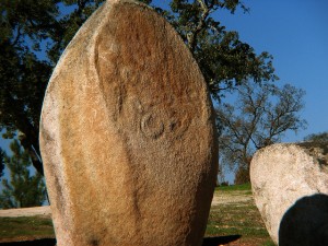
Évora Almendres Cromlech

Évora Almendres Stone Circle. Photo credit: Mick L

I’m moving offices, so I’ve been sorting through the stacks of paper that have failed to find a home in a file folder over the past two years. On top of my stack of archaeoastronomy articles was an analysis of the megalithic enclosures in the historical province of Alentejo in south-central Portugal.* I saved it because I thought it might be relevant to my dissertation (it wasn’t); I re-read it because I had been thinking about the distribution of megaliths across northern Europe while writing about Stonehenge knock-offs yesterday.

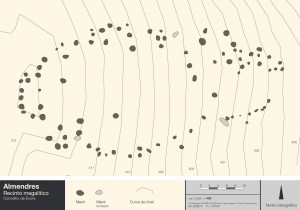
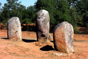
The Alentejo stretches south from the Tejo River to north of the Algarve (Faro District). The Évora district occupies the middle section of the Alentejo. Within the Évora district are twelve known stone enclosures built during the Middle Neolithic period (sixth to fifth millennia B.C.).  Most of the enclosures were built in a horseshoe shape, with openings oriented to the east. The smallest complex, Vale d’el Rei, has twelve menhirs in a simple horseshoe shape; the largest, Almendres, has 94, with a more complicated configuration.

Site Plan, Almendres. Image credit: Pedro Alvin

Site Plan, Almendres. Image credit: Pedro Alvin

A new archaeological survey was conducted of the twelve known sites, including both the location of the extant menhirs and their relationship to the larger landscape (distance to horizon profile, horizon marks, maximum slope, axis of symmetry).** The survey demonstrated that eight of the twelve sites had axes with orientations within a range of 35.4° of azimuth, in approximately the eastern direction. The research team concluded that the probability of this common orientation occurring by chance was very low (~7 x 10^-7), and there could only be two explanations for it:

“either an astronomical target (Sun, Moon, or planets, based on the possible declinations for 6000-5000 B .C.) or a construction following the slope, turned to the direction of the far horizon, since we verified a Pearson product-moment correlation coefficient of .7 between the azimuth of the symmetry axis and the azimuth of the steepest slope.” (p.7)

I’m not sure of what I think of this first conclusion. What about the 1/3 of the sites that didn’t exhibit this commonality? And what about Xarez, which was excluded from the study because of controversial excavations (see **, below), but may have had a different configuration that then twelve sites included the study? At any rate, this initial conclusion motivated the research team to further analyze their data to determine which of the two options was most probable.

Évora Almendres Cromlech.

Évora Almendres Stone Circle. Photo credit: Phillip Capper

The data crunching is impressive and I direct you to the published article to read the description of their probability models (I am not qualified to comment on the validity of Bayesian analysis in this case). Ultimately, the team discarded the possibility that the structures had been positioned in regard to slope. That left them with option two—the stones were arranged in response to an astronomical target. But which target?

It’s possible that the stones had a lunar association—the crescent symbol is engraved on several menhirs in Almendres, Pórtela de Mogos, and Vale Maria do Meio. Most of the engraved surfaces face the east, which could indicate a lunar orientation. On the other hand, it could also indicate a solar orientation, much like that exhibited by the dolmens (stone tombs) in the same region. The builders of the monuments were likely hunters-gatherers-farmers and may have needed the stones as a tool for telling time or marking the seasons. Or maybe not. The authors seemed to hedge their bets, which is common when writing about ancient architectures, but didn’t leave me feeling convinced of their conclusions.

That being said, the tables that accompanied the article are quite valuable. They include menhir statistics (size, location, position, decorations), enclosure statistics (latitude, azimuth of steepest slope, slope, symmetry axis aximuth, declination, horizon altitude), elevation profiles and horizon features of the sites in the study, and site plans for the Almendres, Vale Maria do Meio, Portela de Mogos, Tojal, Cuncos, Sideral, Fontainhas, and Val d’el Rei enclosures. You can also see site plans for many of the enclosures, drawn by Pedro Alvin, at http://www.crookscape.org/sitios.html (scroll to the bottom of the page).

Notes:

*Fernando Pimenta, Luís Tirapicos, and Andrew Smith. “A Bayesian Approach to the Orientations of Central Alentejo Megalithic Enclosures.” Archaeoastronomy 22 (2009): 1-20.

**The archaeological survey did not include the stone circle of Xarez, citing controversial excavation and reconstruction techniques as described in: Manuel Calado, Menires do Alentejo central. Genese e evoluçâo da paisagem Megalitica regional, Lisboa. 2004. Unpublished Ph.D. dissertation. University of Lisbon.

Stonehenge Revisited

8 08 2011
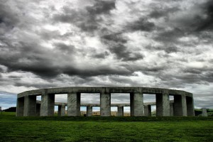
Stonehenge Aotearoa Stormy Sky

Stonehenge Aotearoa Stormy Sky. Photo credit: Chris Picking

True story: when I first visited the Stonehenge Memorial at the Maryhill Museum of Art in Washington State, I didn’t know it was an imitation. I usually attribute my ignorance to my age at the time and my upbringing in a rural area in the dark ages before the Internet, but even with those allowances, you’d think I would’ve learned at some point in grade school that Stonehenge was at Avebury on Salisbury Plain.* Luckily, I was smart enough to keep my mouth shut on the way to Maryhill, where the signage explained that the monument was a replica.

There are so many Stonehenge replicas in the world, some more accurate than other. Of the less accurate but more entertaining variety, Carhenge is probably the most famous. I’ve managed to drive through the State (uh, Official Commonwealth) of Virginia several times without ever stopping at Foamhenge. And, no, I wasn’t at Glastonbury in 2007 to see the construction of Banksy’s Loohenge.

More interesting to me are the models that attempt to establish some relationship between the architecture and astronomy. Although the sentiment behind the Maryhill Stonehenge was misplaced, as a structure, it is carefully designed and well-built, with the altar stone aligned with the sunrise at the summer solstice. Similarly, although Stonehenge Aotearoa was built at a similar scale to the structure at Salisbury, it was aligned for the southern skies. For example, the heel stones of the henge mark the rise and set points of the sun at the midsummer and midwinter solstices, and the autumn and spring equinoxes. In addition, a well-placed obelisk points to the celestial south pole, acting as an axis mundi for the night-time visitor. Specific to the Aotearoa site are stone representing the Pleiades, or the “Seven Sisters”. Maori refer to this group of stars as “Matariki” and use its position mark the beginning of a new year in late May/early June.  To the south-west of this group of stones stands a single marker stone indicating the location of Matariki’s rise.

So, I find the models that attempt to investigate/explain the links between astronomy and architecture more interesting than things like “Butterhenge” or “Peepshenge”. Most interesting of all, however, are the many “real” henges that I only learned about in heritage management courses in graduate school:  Woodhenge, Seahenge, the Ring o’ Brodgar, Stenness (Orkney); the Thornborough Henges, Yorkshire; the Mayburgh Henge, Cumbria; and many others. They intrigue me for the obvious reasons—what do they mean, who built them, how were they built—but as a historian with a research interest in cultural heritage studies, I also find them interesting test cases for public and state preservation policy. How do you approach the management of a wood henge that has been almost completely eroded by the sea? Who has the right to access the inner circle of Stonehenge? Can you copyright a neolithic stone structure?

*By the way, don’t listen to all those people who complain about Stonehenge being a tourist trap and a disappointment just because you can’t touch the stones or buy a decent cup of coffee at the site. Stonehenge is awesome, case closed.


Lunar Landing

7 08 2011
Apollo 11 Coaster, front

Apollo 11 Coaster, front

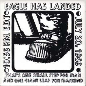
Yesterday, when I was poking around in the Habitat for Humanity ReStore, my partner chased me down and handed me a stack of ceramic coasters. At first I thought she had found a necessary item for our house, since I’ve all but ruined our oak coffee table by letting sweat from my cold glass drip on it, but no. She found something much more interesting—a set of souvenir coasters commemorating the Apollo 11 lunar landing. The graphic is awesomely vintage, with heavy strokes characteristic of graphic design aesthetic of the late 1960s-early 1970s. The astronaut’s boot looks as if it should be accompanied by the “Keep on truckin’!” banner.  The text separators depict (roughly) the four phases of the moon, and the text itself—heavily drop-shadowed—notes two significant events: the landing of the Apollo Lunar Module (LM), Eagle, and Neil Armstrong’s first test of the lunar surface with his foot.

Apollo 11 Coaster, back

Apollo 11 Coaster, back

The back of the coaster tells us that the set hasn’t traveled very far in the world. It was apparently a reward for a successful membership drive for the McKinley YMCA (now the Champaign County YMCA), and we picked it up just a few blocks away from the Y at the Champaign Restore. I like to think that the person who won the set thought they were too special to use, so she or he set them away in a safe place. Maybe they’ve been in that safe place for the last 43 years and they were donated to Habitat for Humanity during a massive cleaning-out project by the recipient’s offspring. Whoever let them go obviously didn’t value them too much, since we picked them up for two bucks, but you know what? They’re going back into a safe place because in this household, they’re too special to use.


First Light

3 08 2011

When the world’s greatest telescopes opened their eyes.


Wallpaper Wednesday

3 08 2011
Westerbork Synthesis Radio Telescope

Westerbork Synthesis Radio Telescope

Today’s lovely wallpaper (click on image to download) shows the Westerbork Synthesis Radio Telescope (WSRT), at the Netherlands Institute for Radio Astronomy (ASTRON), not the Onsala Space Observatory, as the linked page would have you believe. The Westerbork telescope works on the same interferometry principles that determine the design and use of other mobile arrays, such as the Very Large Array (VLA) at the National Radio Astronomy Observatory, the One-Mile Telescope at the Mullard Radio Astronomy Observatory (MRAO), and the Australia Telescope Compact Array at the Paul Wild Observatory. Although you can’t really tell from this photo, one thing that sets this array apart from most is that the telescopes have equatorial, rather than alt-azimuth, mounts.


Herschel Space Observatory

1 08 2011
Oxygen in Orion

Oxygen in Orion. Image credit: ESA/NASA/JPL-Caltech

Very cool:  the large telescope of the Herschel Space Observatory (formerly called Far Infrared and Sub-millimetre Telescope or FIRST) has detected oxygen molecules in the Orion nebula. The existence of oxygen in space makes sense, since it’s the third most common element in the universe. It’s taken something like 230 years for anyone to detect it, though.

The Herschel Space Observatory is one of those projects that demonstrates the benefits of international collaborative efforts. Herschel is a major mission for the European Space Agency, with several nations contributing to the design and build of the instruments and the spacecraft.* However, Herschel is also supported by NASA resources. NASA’s Herschel Project Office is based at JPL, a major contributor for two of the observatory’s three science instruments. JPL itself is a joint project of sorts, since Caltech manages it for NASA. International, multi-national cooperation at its most productive—they found oxygen, after all.

*By my reckoning, Austria, Belgium, Denmark, Finland, France, Germany, Ireland, Italy, Norway, Netherlands, Portugal, Spain, Sweden, Switzerland, the United Kingdom, and the United States all contributed during the industrial phase of the project.


Observatories and Instruments