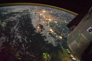
Night view of India-Pakistan borderlands (NASA, International Space Station, 08/21/11). Photo credit: NASA
I don’t write much about my “real” work here, even though this site serves as a repository for ideas and images for future projects. You probably (hopefully) can’t tell, but this blog is actually a textual map of intellectual and geographical connections between observatories and astronomers. The proposal for my next book—assuming I ever finish the one on which I’m working—is hidden in some of my earliest entries.
Today’s image, a view across India and Pakistan from the ISS, is more about my teaching than my research, though. This semester, I’m teaching an undergraduate course on the very broad topic of “urban Asia,” and this week, we’ve been talking about 17-19th-century Lahore. I find myself constantly stumbling over geographical boundaries, saying things like, “in the state we now call Pakistan,” and “India-Pakistan-whatever, at this point, the division is artificial,” and “I know you’re accustomed to thinking of Qandahar as ‘somewhere, over there,’ but at this time, it’s well within the cultural and political world of the Mughals.” In other words, 20th-century borders irritate the heck out of me. It’s difficult to make students see that India and Pakistan under Aurangzeb were same-same. Delhi and Lahore were directly connected by the imperial highway and if you were a Mughal minister, you could just as easily be sent to Kabul as Ujjain.
One of my students asked, “Well, where is Lahore, then?” and the only I answer I had was, “Well…the Panjab, which was less of a state and more of an idea or geography.” As you might expect, that wasn’t a very helpful reply.
This ISS photograph shows that so much of what we think about the world is just a matter of perspective. If you pull back far enough, Delhi and Islamabad can be contained in the same frame of reference.
Click on the image to read NASA’s description of the image and/or to download it in various sizes. You can look at the original image posting here.