Wallpaper Wednesday: SDO and Sunspots

16 07 2014
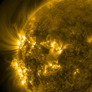
"Sweeping Arches and Loops", solar magnetic activity viewed in the ultraviolet, June 30, 2014.

“Sweeping Arches and Loops”, solar magnetic activity viewed in the ultraviolet, June 30, 2014.

Looking at some of the photos returned by NASA’s Solar Dynamics Observatory (SDO), you’d think contemporary solar observing had little in common with what was being done at Kodaikanal c. 1900-1910. But in addition to the dramatic images of solar loops like the one shown above, SDO also sends back sunspot records that closely resemble the photos and charts produced by C. Michie Smith, John Evershed, and company.

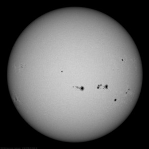
"Spots Galore," July 8, 2014. Image credit: Solar Dynamics Observatory/NASA

“Spots Galore,” July 8, 2014. Image credit: Solar Dynamics Observatory/NASA

According to SDO/NASA:

“The Sun sported a whole slew of substantial sunspots over the past 11 days (July 1-10, 2014). This movie and still show the Sun in filtered white light speckled with more and larger sunspots than we have seen in quite some time. Sunspots are darker, cooler regions on the Sun created by intense magnetic fields poking through the surface. The Sun may have passed its peak level of activity, but it will still be producing many more sunspots and solar storms during the rest of this solar cycle. The still image was taken on July 8 at 22:24 UT.”

Looks familiar!

Visit the NASA/SDO gallery to see more images of solar activity. Like the two above images, most are stills excerpted from videos. Click through each image to reach the links to .mov and .mp4 files.


Upcoming LADEE Launch

2 09 2013
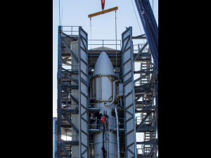
NASA's Lunar Atmosphere and Dust Environment Explorer (LADEE) spacecraft sits in the nose-cone at the top of the full Minotaur V launch vehicle stack.

LADEE in the Fully-Stacked Minotaur V Fairing. Image credit: NASA Ames/ Zion Young

If you’ve been missing your lunar reconnaissance instruments since the GRAIL impact, you might find some relief through the upcoming launch of  the Lunar Atmosphere and Dust Environment Explorer (LADEE). Don’t get too attached to LADEE’s instruments, though—this mission will only last about 160 days. The mission team has allowed thirty days travel time (from Earth to lunar orbit), thirty days for positioning and shake-down, and 100 days for science.

My first reaction to the LADEE project was, “Whoa. You mean we don’t know that already?” Many people feel that the Moon is old hat, a been-there-done-that kind of place. But it turns out we don’t really know much about out closest neighbor, despite the success of the Apollo missions. Did you know that the Moon has an atmosphere? Three of LADEE’s science projects (the Ultraviolet and Visible Light Spectrometer; the Neutral Mass Spectrometer; and the Lunar Dust Experiment) will be studying it through spectral and particle analysis. The fourth component of the payload, the Lunar Laser Communications Demonstration, revolves around a search for a faster means of communicating in space.

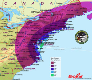
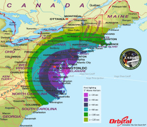
If conditions are right, I should be able to see the LADEE launch Friday, September 6, 2013. More correctly, I should be able to watch the launch vehicle (a Minotaur V) streak across the tree tops at T+90 seconds, give or take a few seconds. The launch window opens at 11:27 p.m. EDT and LADEE will be leaving Earth from the Wallops Flight Facility in eastern Virginia. If you’re on the east coast between North Carolina and the Maritimes, with an open view to the east-north, you might be able to see the rocket. If you fancy a trip out to Wallops, you can find a list of public viewing sites here.

Maximum Elevation Map.  Image courtesty: Orbital

Maximum Elevation Map. Image courtesy: Orbital

From the Orbital Minotaur V website: “This map shows the maximum elevation (degrees above the horizon) that the Minotaur V rocket will reach depending on your location along the east coast. The further away you are from the launch site, the closer to the horizon the rocket will be. As a reference, when you look at your fist with your arm fully outstretched, it spans approximately 10 degrees. Thus if you are in Washington, DC the highest point the Minotaur V will reach is approximately 13 degrees above the horizon, or just slightly more than a fist’s width. The contours shown stop below 5 degrees. It is unlikely that you’ll be able to view the rocket when it is below 5 degrees due to buildings, vegetation, and other terrain features.”

First Site Map. Image courtesy Orbital.

First Site Map. Image courtesy: Orbital

From the Orbital Minotaur V website: “This map shows the rough time at which you can first expect to see the Minotaur V rocket after it is launched. It represents the time at which the rocket will reach 5 degrees above the horizon and varies depending on your location along the east coast. We have selected 5 degrees as it is unlikely that you’ll be able to view the rocket when it is below 5 degrees due to buildings, vegetation, and other terrain features. As a reference, when you look at your fist with your arm fully outstretched, it spans approximately 10 degrees. As an example, using this map when observing from Washington, DC shows that the Minotaur V rocket will reach 5 degrees above the horizon approximately 54 seconds after launch (L + 54 sec).”

Happy LADEE Launch!

ETA: I forgot to tell you that you can follow LADEE on twitter at https://twitter.com/NASALADEE!


Apollo Surface Panoramas

19 07 2013
Apollo 14 Landing Site, Solar Wind Collector. Image courtesy: NASA, Lunar and Planetary Institute

Apollo 14 Landing Site, Solar Wind Collector. Image courtesy: NASA

Warren Harold at the Johnson Space Center has created a great thing: a digital library of panoramic photos of the Apollo landing sites. Even better, the photos are supported with zoom and pan functions, so you can waste an entire morning studying the details of the moon’s surface. My favorite is the Apollo 14 landing site—it’s surreal in its clarity. Click here to go to the Apollo Surface Panorama page at the Lunar and Planetary Institute.


VAB Construction (Wallpaper Wednesday)

20 03 2013
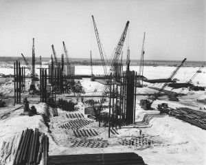
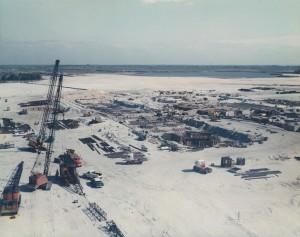
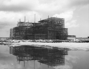
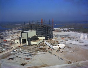
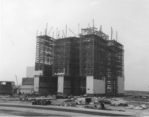
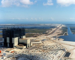
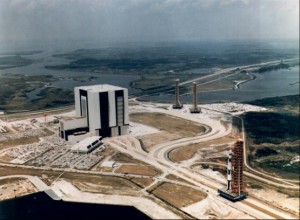
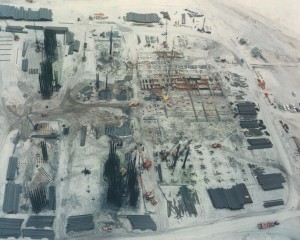
VAB Construction

Vehicle Assembly Building (VAB) under construction with the Launch Control Center (LCC) and LC-39 Service Towers as seen from across the Turning Basin, January 5, 1965. Photo credit: NASA/KSC

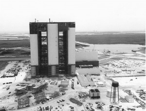
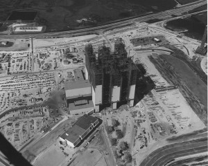
Not enough hours in the day. Here’s some nice VAB construction photos to distract you from the fact that I haven’t written anything of substance here for a while.

VAB under construction, September 1963. Photo credit: NASA/KSC via Library of Congress

VAB under construction, September 1963. Photo credit: NASA/KSC

VAB under construction, October 22, 1963. Photo credit: NASA/KSC

VAB under construction, October 22, 1963. Photo credit: NASA/KSC

VAB under construction, January 14, 1964. Photo credit: NASA/KSC

VAB under construction, January 14, 1964. Photo credit: NASA/KSC

VAB under construction, August 14, 1964. Photo credit: NASA/KSC

VAB under construction, August 14, 1964. Photo credit: NASA/KSC

VAB under construction, November 1964. Image credit: NASA/KSC

VAB under construction, November 1964. Image credit: NASA/KSC

VAB under construction, c. 1965. Image credit: NASA

VAB under construction, c. 1965. Image credit: NASA/KSC

VAB under construction, c. 1965. Image credit: NASA (via Stayne Hoff)

VAB under construction, c. 1965. Image credit: NASA/KSC (via Stayne Hoff)

VAB under construction, June 9, 1965. Photo credit: NASA/KSC

VAB under construction, June 9, 1965. Photo credit: NASA/KSC

VAB under construction, August 1965. Photo credit: NASA/KSC

VAB under construction, August 1965. Photo credit: NASA/KSC


Wallpaper Wednesday (Night View of India-Pakistan)

30 01 2013
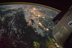
Night view of India-Pakistan borderlands (NASA, International Space Station, 08/21/11). Photo credit: NASA

Night view of India-Pakistan borderlands (NASA, International Space Station, 08/21/11). Photo credit: NASA

I don’t write much about my “real” work here, even though this site serves as a repository for ideas and images for future projects. You probably (hopefully) can’t tell, but this blog is actually a textual map of intellectual and geographical connections between observatories and astronomers. The proposal for my next book—assuming I ever finish the one on which I’m working—is hidden in some of my earliest entries.

Today’s image, a view across India and Pakistan from the ISS, is more about my teaching than my research, though. This semester, I’m teaching an undergraduate course on the very broad topic of “urban Asia,” and this week, we’ve been talking about 17-19th-century Lahore. I find myself constantly stumbling over geographical boundaries, saying things like, “in the state we now call Pakistan,” and “India-Pakistan-whatever, at this point, the division is artificial,” and “I know you’re accustomed to thinking of Qandahar as ‘somewhere, over there,’ but at this time, it’s well within the cultural and political world of the Mughals.” In other words, 20th-century borders irritate the heck out of me. It’s difficult to make students see that India and Pakistan under Aurangzeb were same-same. Delhi and Lahore were directly connected by the imperial highway and if you were a Mughal minister, you could just as easily be sent to Kabul as Ujjain.

One of my students asked, “Well, where is Lahore, then?” and the only I answer I had was, “Well…the Panjab, which was less of a state and more of an idea or geography.” As you might expect, that wasn’t a very helpful reply.

This ISS photograph shows that so much of what we think about the world is just a matter of perspective. If you pull back far enough, Delhi and Islamabad can be contained in the same frame of reference.

Click on the image to read NASA’s description of the image and/or to download it in various sizes. You can look at the original image posting here.


Wallpaper Wednesday (Snow at Baikonur Cosmodrome)

1 01 2013
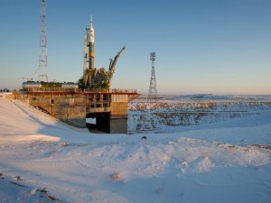
Soyuz TMA-03M at the Launch Pad, 11 December 2011. Photo credit: NASA/Carla Cioffi

Soyuz TMA-03M at the Launch Pad, 11 December 2011. Photo credit: NASA/Carla Cioffi

This is the companion to the Soyuz image I posted a couple of weeks ago. While that one was meant to evoke warm memories of autumnal weather and harvest moons, today’s is a confirmation of the winter weather just beyond my front door. We’re welcoming in 2013 with a foot of snow and freezing temperatures. While I’m generally fond of winter sports and the great outdoors, I’m not sure I’d want to be on the launch crew at Baikonur Cosmodrome during a December launch. I’ll take those warm-weather, 80-degrees-Fahrenheit-in-November launches at Cape Canaveral any day (a shout out to #GaleHouse and its extended family).

Click on the image above to go to the NASA download page.


Wallpaper Wednesday (Soyuz Launch)

19 12 2012
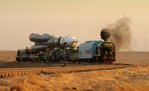
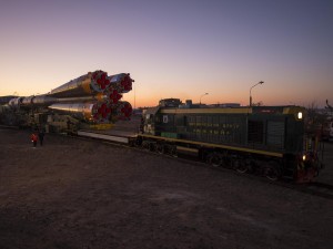
Rollout Soyuz TMA-13 Expedition 18, 10 October 2008

Rollout Soyuz TMA-13 Expedition 18, 10 October 2008

This morning at 07:12:36 EST, the Russian Soyuz TMA-07M Expedition 24 lifted off from the Baikonur Cosmodrome in Kazakhstan. The astronauts on board the spacecraft represent three nations and their space programs. From the Russian Space Agency comes the Commander, Roman Romanenko. Flight Engineer Chris Hadfield represents the Canadian Space Agency and Flight Engineer Thomas Marshburn works for NASA. The Soyuz capsule is on schedule to dock with the ISS on 21 December 2012.

I couldn’t decide what photo to feature today, one that shows this morning’s action or one that represents the longevity of the Soyuz program. I chose the image at the head of this post because it was the most striking in terms of content and the quality of the photography. Soyuz rollouts are so different from the ones we’re used to watching at Kennedy Space Center/Cape Canaveral. With a Soyuz, whether it will be launched from Kazakhstan or French Guiana, the body of the rocket is moved along a horizontal by train and tilted into place on the pad.

soyuz-expedition-31-rollout-1600

Soyuz TMA-04M Expedition 31 Rollout, 15 May 2012. Photo credit: NASA/Bill Ingalls

In contrast, Ariane 5, Atlas V, and Delta IV rockets rollout in the vertical position. Admittedly, the Atlas Vs and Delta IVs tend to be stacked close to the pads, so the rollout doesn’t require a long-distance move. But it seems NASA has always preferred to move a vertical stack—the Space Shuttles and Saturn V rockets were moved along the crawlerway from the VAB to the launch complexes in the upright position, for example.

The First Saturn V Rollout, From the VAB, 25 May 1966. Photo credit: NASA

The First Saturn V Rollout, From the VAB, 25 May 1966. Photo credit: NASA

As you know from my earlier posts, moving things around the planet is almost as interesting to me as putting things in space, so I enjoy photos of Soyuz rollouts almost as much as I do photos of launches. I’ll close this post with the runner up photo, which shows the Soyuz TMA-06M rollout from earlier this year. The side of the train says, “Space Center South.”

Soyuz Rocket Rollout, 21 October 2012. Photo credit: NASA/Bill Ingalls

Soyuz TMA-06M Expedition 33 Rollout, 21 October 2012. Photo credit: NASA/Bill Ingalls


GRAIL Impact: Why now?

13 12 2012

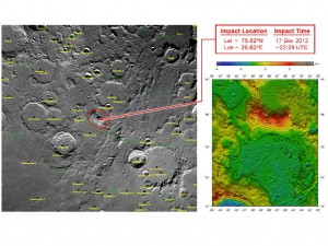
GRAIL’s Final Resting Spot. Image courtesy: NASA/GSFC

A little over a year ago, I posted an image of Delta II rocket on its pad to mark the launch of NASA’s GRAIL mission. Today, I’m posting a map of the Moon that shows where the GRAIL spacecrafts will hit on Monday (17 Dec 2012). The twin probes were always meant to be disposable; once they’d completed their mission (mapping the Moon’s gravitational field), they were to be crashed deliberately into the lunar surface.

NASA could just let “Ebb and Flow” die a natural death, so to speak. The twins aren’t quite empty of fuel yet, but eventually, they would find their own way to the lunar surface. If you chased down the article I mentioned yesterday and read its final section, however, you already know why NASA is reluctant to let that happen.[1] Two words: lunar heritage.

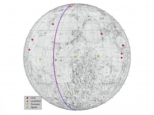
Lunar Heritage Sites and GRAIL’s Final Mile. Image courtesy: NASA/JPL-Caltech

The map above shows all the sites NASA considers “heritage” (click to enlarge). The Apollo landing sites are marked in green. The Surveyor sites are yellow. Russia’s Lunakhod landing sites are red triangles; their Luna landing sites are red squares (unintentionally funny?). As recently as 2009, when Launius published his article on space heritage, very little discussion had taken place on the safeguarding or preservation of any lunar landing sites, American or Russian. It’s difficult to say what prompted the sudden surge of concern, but my educated guesses are:

  • Successes of private entities like SpaceX make NASA nervous. It was probably difficult to imagine a real threat to something located on the moon. It’s not so difficult to imagine it today, though.
  • Less pressing, I think, is the possibility that another nation will land on the Moon and lay claim to what the United States and the Soviet Union (Russia) left behind. It may happen, but not before SpaceX gets there.
  • State entities pushing on federal policies. For instance, in 2010, the California State Historical Resources Commission voted to include the Apollo 11 landing site and relics on the California Register of Historical Resources. New Mexico has also laid claim to it as state heritage. This  leads to more pressure for Tranquility Base to be named as a National Historic Landmark.
  • Expansion of the nominating criteria/categories for inclusion on UNESCO’s World Heritage List. Tranquility Base has already been nominated for inclusion once on the list. At one time, the list included only architectural monuments. From there it has expanded to include gardens, cultural landscapes, intangible heritage, underwater sites, and natural sites. It’s only a matter of time before World also means Universe.
  • The Lunar Reconnaissance Orbiter Camera has made it clear that there are artifacts involved, not just activity. In theory, the 2008 Convention for the Safeguarding of Intangible Cultural Heritage could be stretched to cover “space exploration” as a significant cultural practice, but significant space detritus is more likely to be included on the World Heritage List.

We’ve only begun to talk about the issues at stake—the difference between “space history” and “space heritage,” who owns the Moon, who owns the Universe, why do we keep throwing things away in space. Hopefully, policy will evolve along with our thought processes. In the meantime, I encourage you to track down Launius’ article, which represents some of the current thinking on the subject.

————————–

[1] Roger D. Launius, “Abandoned in Place: Interpreting the U.S. Material Culture of the Moon Race,” The Public Historian, Vol. 31, No. 3 (Summer 2009), 9-38. (e-mail me if you can’t find a copy of this article!)
Wallpaper Wednesday (Abandon in Place)

12 12 2012

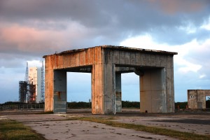
Abandon in Place (Courage). Photo credit: JR

Today I’m giving you my own photo. Until last week, it was on exhibit at the Museum of Flight in Seattle as part of the “2012 Spirit of Flight” show. The photos are no longer on display, but I’ve been writing up a short statement about NASA’s preservation policies to include in the most recent version of my portfolio and this image is at the center of my theorizing right now.

If you’re not familiar with LC 34, it was the site of the Apollo 1 fire that killed astronauts Virgil “Gus” Grissom, Edward H. White, and Roger B. Chaffee. NASA used the launch complex (with modifications) through the Apollo 7 launch in 1968, after which time the Apollo program moved to LC 39A & 39B. According to a 2007 report produced during an Historic American Engineering Record (HAER) survey, LC 34 was mothballed by NASA in November 1971 and abandoned in October 1973 (if you zoom in on the forward leg of the platform, you can see the “ABANDON IN PLACE” stencil).[1] The complex officially belongs to the Cape Canaveral Air Force Station National Historic Landmark  District today.

If you’ve been out to LC 34, you’ve probably noticed two things. First, it’s quiet and peaceful on the pad, even if you’re surrounded by dozens of spacetweeps. Part of the tranquility comes from the reverence with which space enthusiasts approach the site, of course, but most of it comes from its relatively remote location. And that’s the second thing: LC 34 is quite distant from the Kennedy Space Center Visitor Complex and the “special access” tours don’t seem to go there these days.[2] The launch pad hasn’t quite been abandoned—a trio of benches and a Historic Site Kiosk stand at the concrete’s edge—but it isn’t being maintained as much as you might think it would be, given the events that occurred there.

This observation isn’t new. Roger Launius, Senior Curator in the Division of Space History at the Smithsonian Institution’s National Air and Space Museum in Washington, D.C (aka “the man who has the job I really, really want”), noted some years ago that in this case, “ABANDON IN PLACE” really means just that: no one is care-taking this piece of our (American, global, space, scientific, cultural) heritage.[3] Launius provides several good explanations—launch structures are constantly being dismantled, adapted, and redeployed to serve the next rocket design, NASA’s cash-poor state makes it difficult to initiate, much less sustain, a preservation program, NASA’s reluctance to part with artifacts, etc.—but I can’t help but think none really explain the status of LC 34.

I’d like to think that that undeveloped state of LC 34 was a conscious decision on the part of the CCAFS to leave things as close to the past as they could possibly be. Better interpretive signage would be a nice addition, but seeing the pad in it’s “natural state” is more moving than viewing it from behind a protective fence or under a spotlight. However, I suspect the real reason the platform is being left to decay is because the CCAFS doesn’t want tourists spending any more time than necessary at their top secret military satellite-weapon launch site. Add to that any financial concerns the Air Force might have about “wasting” money on history rather than war and I think you’ve got a fuller explanation.

Click  on the image to download and enjoy.

——————–

[1] Historic American Engineering Record, Cape Canaveral Air Force Station, Launch Complex 34 Operations Support Building, HAER No. FL-8-AN.

[2] I’m not sure if this is permanent or not. Until recently (2010?), the KSCVC ran a “Cape Canaveral: Then and Now” tour that went to LC 34. At present, that tour isn’t on the list of the available options, though.

[3] Roger D. Launius, “Abandoned in Place: Interpreting the U.S. Material Culture of the Moon Race,” The Public Historian, Vol. 31, No. 3 (Summer 2009), 9-38. (e-mail me if you can’t find a copy of this article!)


Toward a History of the Space Shuttle

27 11 2012

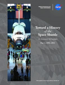
I was very excited to see an announcement from NASA’s Communication Support Services Center in my inbox today, because only good things ever come from that office. Today’s e-mail directed me to the download site for a new NASA e-book, Toward a History of the Space Shuttle: An Annotated Bibliography Part 2, 1992–2011, compiled by Malinda K. Goodrich, Alice R. Buchalter, and Patrick M. Miller of the Federal Research Division, Library of Congress.

So exciting! If you’ve ever looked at the 1992 edition of Toward a History of the Space Shuttle An Annotated Bibliography compiled by Roger D. Launius and Aaron K. Gillette, you probably have a sense of what’s in this new edition. In short: everything. I’m reproducing the table of contents for you here, just in case you doubt my word (click on each image to make them larger).

Table of Contents, Toward a History of the Space Shuttle: An Annotated Bibliography, 1992

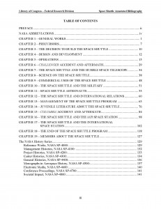
Table of Contents, Toward a History of the Space Shuttle: An Annotated Bibliography Part 2, 1992–2011, 2012

Any book, article, or bulletin even remotely related to the Space Shuttle program is likely to be cited in one or the other volume. The annotations cover popular publications (Popular Science, Washington Post), professional journals (Nature, Journal of the British Interplanetary Society), and technical/government reports (U.S. General Accounting Office, U.S. Congress).

Some neat things about the second volume: it opens with a list of abbreviations, a necessary tool when you’re reading NASA; it contains annotations for DVDs, so you can get your space on in front of the television; it covers children’s books, so you can get you kids in on it; and most usefully, the new volume has embedded links that connect to the parallel section in the first volume.


Observatories and Instruments